Day 1 (May 10, 2021): Adel to Hart Mtn Hot Springs, 46 Miles, 14 Gravel
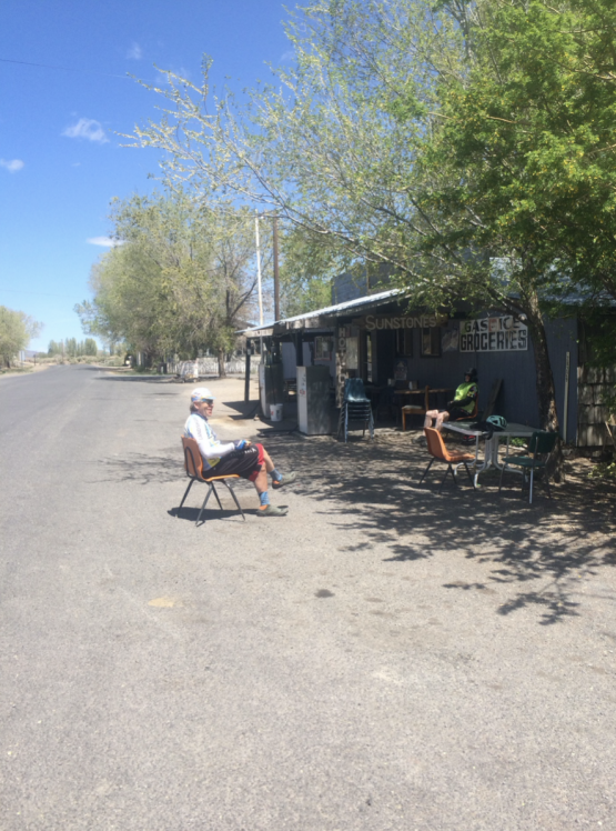
After having to cancel this trip the year before due to COVID-19 concerns I am elated that it is finally becoming reality. It all starts in the small hamlet of Adel on Hwy 140. I meet my riding partners Russ, Jeff and Alden in front of the Adel Store, a combination of Store, Restaurant, Bar and Gas Station. We get permission from the owner to park our cars in front of the business under a big elm tree. When they hear about our itinerary they are surprised and offer (jokingly?) to call the Lake County Sherriff Search and Rescue if we are not back three days after our planned return on Friday afternoon.
We do a bit of last minute packing and are on the road at about 10 AM. Fresh legs and excitement to finally be riding makes the first few miles fly by quickly. The road is paved and traffic is almost non-existent. Far to the north we can make out the silhouette of Hart Mountain, our destination for today. An hour has gone by when we run into an obstacle. A cattle drive is happening on the road in front of us. About 200 cows are walking on the pavement. We are approaching carefully and talk to the cowboy who is riding his horse in the back. He advised us to just slowly ride right thru the cows without scaring the animals. We follow his advice and try not to get splattered with too much green cow shit.
After 18 miles we make it to the small town of Plush and stop at the Plush Store, the only place to buy anything for today and the next 83 miles. The local mailman is just delivering some packets to the store and has time for a little conversation. We complement him on the nice little town and he said that it was a lot better before the electricity came to town and the road was paved. “Too much traffic nowadays!” he says. Hmm, we see about two vehicles come by in about ½ hour…
After an Ice cream bar we continue on our way north through the Warner Valley along a series of shallow lakes. We see a lot of birds and other wildlife. Finally the pavement ends and the rough gravel road turns east and steeply uphill. We are entering the Hart Mountain National Antelope refuge. This refuge covers 422 square miles. We struggle to climb the steep road with our heavily packed bikes under the searing afternoon sun. Finally we make it to a look-out spot and take a well-earned break. Our water bottles are getting lighter quickly. Our next water spot a spigot at the Refuge Headquarters several miles up the hill. We fill up there and splash our faces with clean, cold water. I admire the beautiful stone buildings of the Headquarter buildings constructed around 1935. We have about 4 uphill miles to ride to our final destination for the day. A primitive campground at the Hart Mountain Hot springs. When we get there the sun has already gone down behind the hills and the air is getting quite chilly. We quickly set up our tents and walk over to the concrete reservoir that collects the hot water from the spring. Our sore muscles welcome the warmth of the water and we feel like we are melting. We make sure not to stay in the hot water too long to avoid passing out. Night comes quickly and we crawl into our tents early.
Day 2: Hart Mtn Hot Springs to Frenchglen, 55 Miles, 45 Gravel
In the middle of the night I am awoken by strange crunching noises. In the dark I grope around for my headlamp and open the tent zipper. Right in front of my face I see a cute little Kangaroo rat chewing a hole into an empty aluminum pouch left over from my freeze dried dinner. I am relieved that the little rascal only chewed up a piece of garbage and not my shoes or my tent.
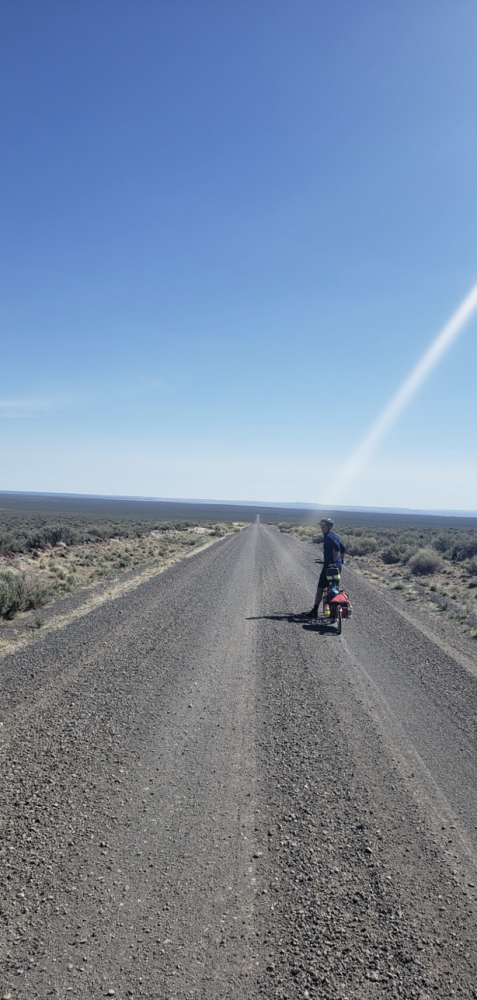
The night was very cold. I pull my riding clothes into my sleeping bag to get them warm enough to put on. Last night I draped my wet towel over a bush to dry it. This morning it is frozen stiff. Everybody eats their breakfast of choice. I havemy usual mix of hot chocolate and coffee, Buffalo pepperoni and cheese sticks on an onion bagel. We pack the bikes and head back down to the Headquarters where we re-fill our water containers for the long and dry ride thru the Antelope Refuge to Frenchglen. The wash boarded gravel road is straight as a ruler and far in the distance we can see the skyline of the snow-covered Steens Mountains. At times we spot the Prong-horn antelopes running at full speed through the sagebrush prairie. 9 miles before Frenchglen we are back on pavement. It feels really fast and smooth and our sore backs welcome the relief from the harsh washboard bumps. Frenchglen’s population is listed as 12. Most of them are probably working in the historic hotel or in the Frenchglen Mercantile next door. We buy some supplies and I get a delicious ice cream bar which I devour on the spot.
After a good rest on the wood bench outside the store we ride 3 more gravel miles to the Steen’s Mountain Wilderness resort located near the Donner and Blitzen river. Here we find a comfortable campsite on green grass. We even get the luxury of a real shower.
Day 3: Frenchglen to Alvord Hot Springs, 86 Miles, 53 Gravel/Dirt
We rise earlyin the morning because we know that this day is going to be long and strenuous. As I stumble out of my tent I notice that the zipper on the duffle bag on my bike trailer is partially open and some stuff is bulging out. I check it out and discover that something has gotten into the bag and stolen most of my oatmeal cookies which I had carried since the start in Adel. When Russ gets up he tells me that he heard some Raccoons last night and that he chased them off my belongings. I thank him for that because if he hadn’t chased them off I would have lost a lot more food which I was counting on for the next days.
Russ likes to take his time in the mornings and we decide to start without him and regroup in the tiny outpost of Diamond about 30 miles up the road. We enjoy a flat ride on good pavement with very nice weather and great scenery along another wildlife refuge.
After XX miles we leave the main road to Burns and turn east thru beautiful ranch land to the little settlement of Diamond at the end of the paved road. This unincorporated community was settled in 1874 and was named after the Diamond Ranch. Today not much is left except a few crumbling stone buildings and the historic Diamond Hotel which is still operating today. We had hoped to be able to eat lunch there but we find out that they only serve Dinner and by appointment only. We are able to buy some cold drinks and snacks which we enjoy on the green grass beside in the shady side yard of the hotel. I ask the owner if they heard of anybody coming or going our planned route leading over the north flank of the Steen’s along Stonehouse canyon. One old man says ominously: “Nobody in their right mind!” We are not quite sure on how to take that comment…
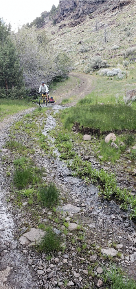
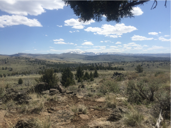
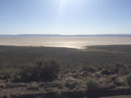
After a little while Russ joins us and soon we are starting the climb up the gravel road to the Kiger Mustang Viewing Area, our planned lunch spot for the day. We are now inside the BLM Kiger Mustang herd management area which extends over 30,000 acres ( 120 square Km) along the Kiger Gorge and Kiger Creek. The Kiger Mustangs wild horses believed to be direct descendants of horses brought by the Spanish Conquistadores. Climbing up the dirt road we notice less and less tire tracks in the dust. We keep our eyes open for wild horses but no luck. The only sign of the horses are a few “Stud Piles”, mounds of accumulated horse poop. This is a way for the Mustangs to mark their Territory. As the hours get close to noon the temperature is getting hot and we eat our meager lunches on a hill under a gnarly old Juniper Tree. The “road” ahead is a faint track through dry sagebrush covered hills until it finally crests over the northern flank of the Steens Mountain Range. We are elated when we finally hit the top. There at about 6900’ we find the last remnant of a snow drift. Glad to be finally pointing downhill we push through the welcoming cool snow. We now enter Stonehouse Canyon. It is a steep and rocky dirt road that plunges down to the Alvord desert. The road is so steep in some places that Russ and Jeff decide to walk their bike to avoid crashing. We are crossing Stonehouse creek and decide to fill our water containers because we know that this is the last running water for a long stretch. It is late afternoon when we finally make it to the gravel road that runs on the bottom of the Steens mountain range along the Alvord desert. The sun is ready to go down behind the ridge when we turn south. We put our heads down and grind out 20 more dusty miles. The road is decent compared to what we have been through but the loose gravel saps what power is left in our legs. A cold hard wind is blowing from the west off the mountain with gusts so strong that at times we are in danger of being blown down off our bikes. It is dark when we finally spot a faint light in the distance. It comes from the Alvord Hot Springs at the edge of the Alvord Playa, a big salt flat that stretches for many square miles to the east. After 13 hours of hard riding we finally make it to today’s destination. The Hot Springs are on private property and consists of two hot pools lined with rocks and some windbreaks constructed of old timbers and rusting corrugated sheet metal. We set up our tents on the gravel parking area because the remaining areas are full of “goat heads”, spiny seedpods that wreak havoc on bicycle tires. We discover that the water in the restroom is very alkaline and not drinkable. Everybody uses their last water reserves to wash down a hurried meal. Only a few venture out into the hot springs . I nearly pass out from exhaustion sitting in the hot water. I find my way to my tent in the dim light of my headlamp and fall asleep before I can zip up my sleeping bag.
Day 4: Alvord Hot Springs to Virgin Valley CG, 75 Miles, 21 Gravel
We wake up to another clear and warm day. The campground has a little shack where they sell bottled drinking water and some minor snacks like candy bars and potato chips. But this morning the store is still closed because the young lady who runs the business is still sleeping in her trailer after a night of partying with the local ranch workers in the hot springs. Everybody is out of drinking water and we make coffee with the salty water from the bathroom sink. Not recommendable. Next to our tents a fellow traveler is trying to start his old pickup truck. Russ goes over and helps him to get his truck started. When he hears our laments about the lack of suitable drinking water he graciously gives us a gallon plastic bottle of water from his provisions. We thank him and after dividing the water amongst us we pack up and head out. The morning sun reflects of the bright white surface of the plaza as we ride south towards the little settlement of Fields. I almost roll over a big rattlesnake that is soaking up the warmth of the sun in the middle of the deserted gravel road. A few miles before Fields the gravel turns into smooth asphalt pavement. What a treat after the harsh surface conditions of the last few days!
Fields (140 inhabitants) is located at the junction with the road that leads to Frenchglen following the western slope of the Steen and near the Pueblo Mountains. It is a veritable Oasis for us. We fill our containers with fresh, cold water from a community well and wash our salt crusted faces. Then we have a huge lunch at the Fields Station, a combination of gas station, store and restaurant. Greasy burgers and milkshakes never tasted so good. With full stomachs but refreshed we are ready to tackle the next 25 miles to Denio There we cross over into the State of Nevada. Not much to see there beside a few scattered old dwellings and a Saloon, which we bypass because we still have about 30 miles to ride to our destination. 3 miles south of Denio we stop at Denio Junction on Highway 140. a dusty combination of Gas Station, Motel and restaurant with a few slot machines. It is run by a young couple with two small children. A lonely place to raise a family. On Highway 140 we turn west again and grind out the remaining 25 miles. A strong headwind is making live tough for us but we put our heads down and finally make it to the turn-off to the Virgin Valley hot springs which is situated in a wildlife refuge. Three more miles on a bumpy gravel road and we arrive at our oasis for the last night of our trip. There is a nice pool of warm, not hot, water and an old stone shower building. The showers are fed by the warm springs and run 24 hours. It feels so good to dive in and get the road grime off our bodies. The campground is free of charge and exists of a big gravel parking lot and a few camp sites scattered in the bushes and sagebrush. We find a place that is sheltered from the wind and even have a very small camp fire for the first and only time on this trip.
Virgin Valley CG to Adel, 59 Miles, 3 miles Gravel
We get up early for our last day. We eat what we have left in our bags and leave enough for a lunch. But we make sure we have filled up all our water containers. There is no water or any kind of service on this part of the trip until we get back to our starting point in Adel. The landscape consists of wide open spaces and is characterized by Basin and Range geology. (google it!). The day’s work starts off with a looong climb and a fast descend on the other side. This will repeat many times. Nothing but sagebrush covered hills and valleys. You can see for miles and miles before the dark band of pavement disappears over the horizon. Despite the remoteness we are aware that today we are on a major highway with more frequent and faster vehicle traffic. But mostly we can spot an approaching car or Truck a long time in advance. Except when we get close to the Nevada-Oregon border. There we climb up one of the few winding stretches of highway. Before a tight corner without sight distance a motorhome passes us and gets halfway into the other lane just when an oncoming motorcycle rounds the corner. Luckily for everybody involved the motorcyclist is a very skilled driver and can just evade a head-on accident with the motorhome. We are a bit shaken up and count our blessings. We stop for lunch on top of Doherty Slide, a high rimrock formation just inside of the Oregon border. We enjoy the fantastic view and the high speed downhill afterwards. After many more climbs and downhills we finally see the green oasis of Adel in the distance. The last few miles seem to get longer the closer we get to the end. Finally we get there and find our cars still waiting for us under the big shade tree. Before we start the long drive home we have big hamburgers at the Store and celebrate the good outcome of our little adventure.
See you out there!
About the Author: Michael Schaaf. Born 1955 in Bremen, Kreis Soest, Germany. Emigrated to USA in 1980. Registered Professional Civil Engineer, Oregon. Retired in 2016 from Oregon Department of Transportation. Married, two children, four grandchildren. Lives in Klamath Falls, Oregon.