August 11, 2021 to August 12, 2021
It had had an active day and was ready to get off of the couch and go to bed. Suddenly a call for volunteers comes in by text message from the SAR Sherriff’s Deputy at around 22:00: “Injured female on the PCT. Strong hikers needed. Report to compound if available”. Rescue missions on the PCT (Pacific Crest Trail) often involve long hikes in remote areas, often without radio or cell phone communication. After a short hesitation I decided that I was not too tired to go on this mission. I put on my usual SAR gear and grabbed my SAR backpack and hiking stick. The clothing and pack hang on the wall near my back door, always ready for deployment on a moment’s notice. The pack contains all the essential gear for a typical SAR mission lasting up to 24 hours. I climb into my pickup truck and speed to the SAR compound about 5 miles from my house. At the compound I meet two fellow volunteers, Mike and Gary. We pull one of the big SAR pickup trucks out of the garage and drive about an hour to get to the Sevenmile Trailhead where we meet the Sherriff’s Deputy in charge of the mission. The Deputy briefs us on the situation: “A 30 year old female hiker fell on the trail. Her name is “Sylvia” (Name changed to protect privacy) She has a head wound, an injuredthumb and bad back pain. She is camped near an area called Jack’s Spring and lays in her tent. Because of the possible serious injury a request for a helicopter evacuation has been made by the Sherriff’s office. The chopper might be available at 0700 tomorrow”. We are given GPS coordinates from the location of her emergency beacon message. I am the team leader for today’s mission and decide that Mike and I will hike and Gary will stay with the vehicle and monitor the two-way radio. Mike and I adjust the contents of our bags, leaving behind all gear we deem unnecessary for this mission and include first aid supplies and extra water. At around midnight we finally set out on the trail.
Our packs are heavy with the extra gear and supplies. The night temperatures are mild and soon we start to work up a good sweat. We are on the Seven Lake Basin Trail follows the Sevenmile Creek up a steep incline for about a distance of 2 miles until it reaches the PCT. At the junction with the PCT we take a short break and adjust our packs and clothing. At this point we are still within radio communication with Gary and the Deputy at the trailhead but we know that radio coverage will be spotty or nonexistent from here on out. We turn north on the PCT at the junction. The night is dark and we are glad to have brought extra batteries for our headlamps and GPS devices. The trail heads straight north on the west side of smaller volcanic cones named Maude, Ruth and Ethel, the three sisters. On the way we come across a small tent pitched in a small clearing besides the trail. We wake up the occupant and ask him if he had seen or heard of Sylvia. Even though we have GPS coordinates of the origin of Sylvia’s emergency message we want to be careful to not miss her somehow. The weary sleeper is not happy about the disturbance and grunts at us that he doesn’t know Sylvia. Onward we go. Our progress is hindered at times by trees that have fallen across the trail. This part of the PCT is fairly remote and receives little regular maintenance. We are starting to get a bit tired and are getting hypnotized by the dancing lights of our headlamps. Suddenly we hear a crashing sound in the trees on the downhill side of the trail. We stop to take a look, but our lights are not strong enough to penetrate the darkness for very far. But against the pitch black background we see the bright reflections of a pair of eyes! The eyeballs are too far spaced to belong to a smaller animal. We assume that it is a bear that watches us curiously. Black bears in this part of the mountains are not known to be aggressive and we are not too concerned for our safety. We didn’t bring any bear spray to avoid the substantial weight penalty. The (assumed) bear follows us for quite some time but finally the glowing eyeballs disappear in the darkness and we are a little relieved.
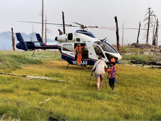
The trail continues around the east flank of Lone Wolf, another volcanic cinder cone, and soon we drop into a small valley and reach a junction with a short spur trail to Jack’s Spring. It is the first big level area since we started hiking. The place is filled with the pup tents of PCT hikers. Even though we are not quite to our given coordinates we assume that Sylvia’s camp would be one of the approximately dozen tents. We go from tent to tent and ask the drowsy hikers if they are or know of Sylvia. Some of the people are understandably grumpy, some are confused and some are very appreciative of our effort. Finally one person states that he has seen Sylvia in the evening limping thru camp but he didn’t speak to her but observed her continuing north on the Trail. Mike and I thank him for the info and we keep hiking towards our coordinates. And sure enough, after about a ¼ mile we see a yellow pup tent next to the trail. Through the closed tent door we introduce ourselves and we find out that it is Sylvia. I speak to her and ask her about the extent of her injuries. She lets me look inside the tent to try to assess her condition. She has a bump on her left forehead with a small head wound that is not bleeding anymore. Her right thumb joint is swollen and painful. She states that her back is hurting and that she has difficulties walking. I tell her that a Helicopter might be able to pick her up in the morning. At this point we don’t know if the Helicopter is going to be available. I tell Sylvia to rest and that we will help her pack at daylight. Mike and I leave our packs near the tent and hike back south on the trail to a point on a ridge where we had the last radio contact. We manage to get some scratchy reception and report that we found the person. We were assured that the chopper would be at the given coordinates at 0700. By this time it is almost 0330 and we are very tired. We hike back to Sylvia’s camp and make us comfortable as we can on a small flat area covered in pine needles. I set the alarm on my phone for 0500, lay down on the ground with my head propped on my pack and doze off for about an hour. Soon the first light creeps through the trees from the east. Mike and I stretch our backs and legs and eat a breakfast consisting of an energy bar washed down with a few swigs of water. Now it is time to scope out a suitable landing zone (LZ) for the Helicopter. We look at the topo map and decide to check out a high spot close to hour camp. When we get to the top we realize that there are too many closely spaced trees to allow for a safe landing. Another look at the topo map shows an area of some semi dry small lakes nearby. Mike hikes back to camp to check on Sylvia while I continue to the prospective LZ. It turns out that the lakes, or better said puddles, are dry at this time of the year. A fire went thru this area years ago and left only a few denuded trunks. A perfect Landing Zone and very close to our camp. I hurry back to camp and find that mike has packed Sylvia’s tent and belongings. Sylvia sits on a log and is struggling to put on her low top hiking shoes. Her back is still hurting. I help her slip into the shoes and tie her laces. Now we need to hurry to get to the LZ by the arranged pickup time of 0700. Sylvia is using her hiking poles for support but can only move very slowly while Mike is carrying her pack and his own load. We make it to the LZ with about 5 Minutes to spare. We rest on some boulders on the far edge of the open area. Our bright reflective coats should be very visible from the air against the dark background of grass and moss. At almost exactly 0700 we hear the chopper approaching from the south west and soon he is above us. They circle the area repeatedly to check for any dangerous trees and then slowly lower down to the ground. We wait for the pilot to give us the sign to approach the aircraft. The two crew members, the doorman and a flight nurse are helping Sylvia into her seat and load her pack. To our dismay Mike and I are told that there is no room for the two of us on board. But if the delivery goes well and the fuel situation looks good they might be able to return to us and give us a ride out. With this they take off and quickly disappear over the horizon. I know that the delivery point where an ambulance is waiting is only about 11 miles away. We are very tired at this point and dread the thought of the 4 hour hike back to the trailhead. So we just try to get some rest and enjoy the warmth of the morning sun and eat some snacks. After about 15 minutes the Heli is back and we limb abort. We buckle up and lift off. I enjoy the view high above the familiar terrain and soon we touch down at a paved parking lot at the Annie creek Snowpark area. There the Deputy and Gary await us and after a quick debriefing we are driving back to the SAR compound in Klamath Falls. I can’t keep from dozing off. It has been a long day…
About the Author: Michael Schaaf. Born 1955 in Bremen, Kreis Soest, Germany. Emigrated to USA in 1980. Registered Professional Civil Engineer, Oregon. Retired in 2016 from Oregon Department of Transportation. Married, two children, four grandchildren. Lives in Klamath Falls, Oregon. Volunteer with the Klamath County Sherriff’s Search and Rescue Unit since 2016.